
Sharing your general location with someone is easy. Unfortunately, thanks to location tracking errors, getting someone’s precise location isn’t always accurate, especially in dense urban areas. Google is aware of these limitations and today unveiled steps they’ve taken to improve urban GPS tracking on Android phones.
As part of the latest Pixel Feature Drop, Google is rolling out version 2 of its 3D mapping aided GPS corrections to the Pixel 5 and Pixel 4a 5G, which features accuracy in urban areas that “improves spectacularly” over what’s currently available.
The issue with locating someone in an urban area is due to the density of buildings. Google explains that GPS systems are based on line-of-sight operation from satellites. In cities, most signals reach devices through non-line-of-sight reflections, because direct signals are blocked by buildings. “The GPS chip assumes that the signal is line-of-sight and therefore introduces error when it calculates the excess path length that the signals traveled,” Google said.
![]()
![]()
“Picture of a pedestrian test, with Pixel 5 phone, walking along one side of the street, then the other. Yellow = Path followed, Red = without 3D mapping aided corrections, Blue = with 3D mapping aided corrections.” Caption and image credits: Google.
Google’s latest feature is aided by signals from the USA’s Global Positioning System (GPS) as well as other Global Navigation Satellite Systems (GNSSs). One of the biggest benefits of these improvements is ridesharing apps will no longer see inaccurate locations, like when a customer is mistakenly placed across the street.
“This wrong-side-of-the-street position error is caused by reflected GPS signals in cities, and we embarked on an ambitious project to help solve this great problem in GPS,” Google said. “Our solution uses 3D mapping aided corrections, and is only feasible to be done at scale by Google because it comprises 3D building models, raw GPS measurements, and machine learning.”
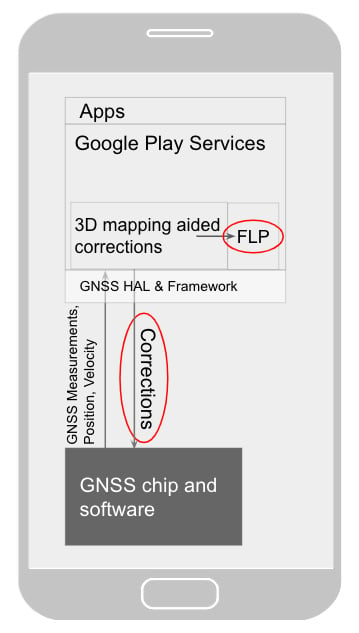
Google said with version 2 of 3D mapping aided corrections, wrong-side-of-street occurrences dropped by 75%. Other Android phones with version 1 of 3D mapping aided corrections reduced wrong-side-of-street errors by 50%. Google plans to bring version 2 to all devices running Android 8 or later in 2021. The new 3D mapping aided corrections module will arrive as an update to Google Play Services, which is available on all Android devices with Google Mobile Services. App developers can call the Fused Location Provider API (FLP) to get location information which will benefit from this improvement to location tracking.
As of now, the company’s 3D mapping aided corrections module features tiles of 3D building models for more than 3,850 cities across the globe, so there’s plenty of coverage. The feature supports pedestrian use-cases only, like when you’re walking, but will support other modes of travel, including driving, in the future.
To see what else was added in the latest Pixel Feature Drop, check out our coverage. You can also learn more about how Google is improving GPS accuracy by following the source link.
The post Urban GPS tracking will get way more accurate on many Android phones next year appeared first on xda-developers.